Arizona
10 Arizona Places That Look Fake—but You Can Actually Visit
Sandstone folds, purple badlands and granite islands are real. Here are ten extraordinary landscapes—and the guides, roads, walks and current restrictions that shape a worthwhile visit.
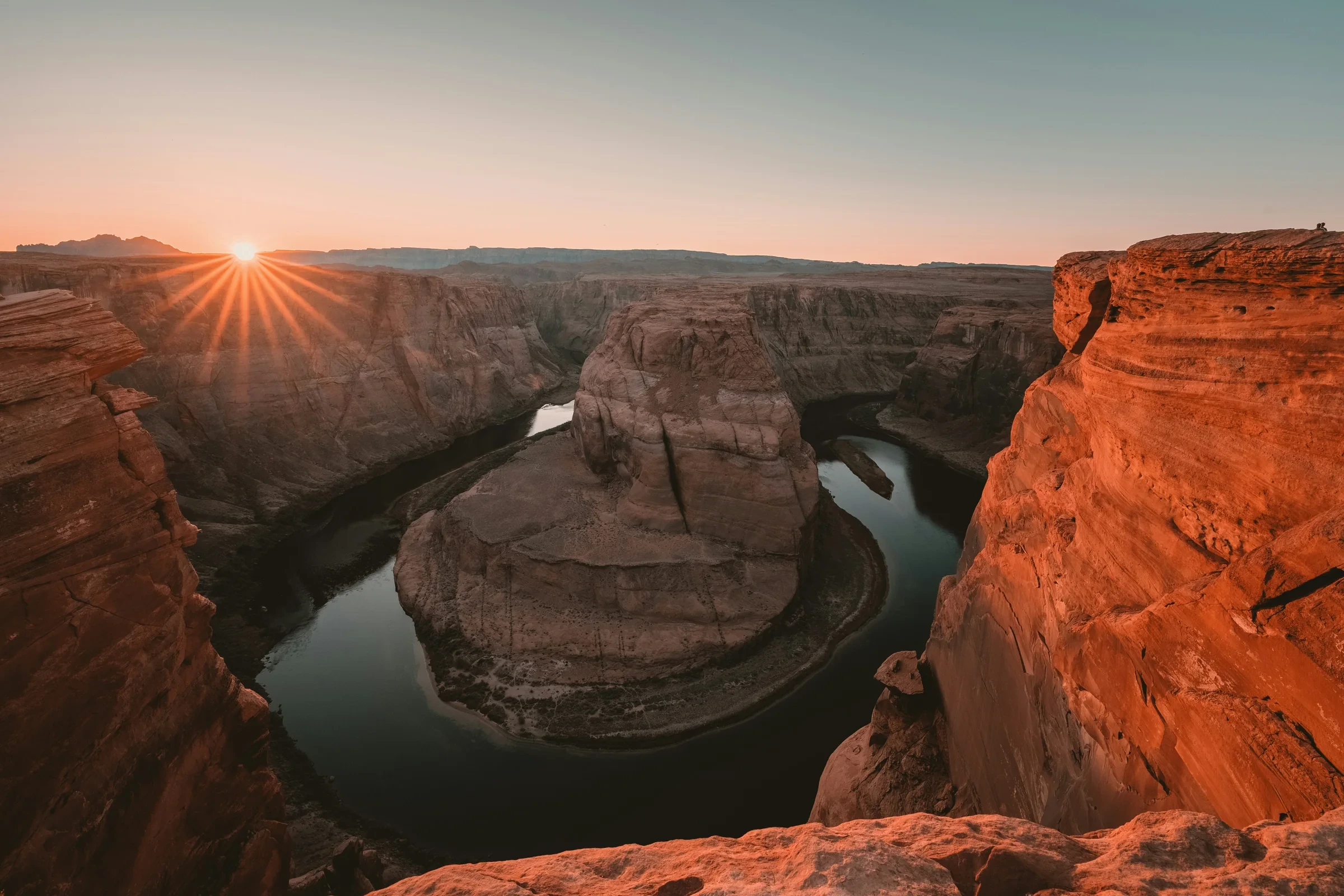
A river curls around a solitary butte. Pale sandstone buckles into waves. Purple hills hold the remains of trees turned to quartz. Arizona has landscapes that make you stop scrolling and wonder whether the scene is real. These ten are—and each has a legitimate way to visit, from paved viewpoints to guided tours and carefully planned remote excursions. The important differences are in the access. This guide uses authentic photographs and official visitor information checked October 14, 2026, including current closures; the images are not a record of today’s conditions.
At a glance
- Scope
- 10 landscapes across Arizona; Monument Valley also extends into Utah.
- Plan first
- Antelope Canyon needs a guide; White Pocket requires serious vehicle planning.
- Current limits
- Tonto’s lower trails are closed; Canyon de Chelly lists White House Overlook and Trail as closed. Checked October 14, 2026.
1. Horseshoe Bend: a river that almost doubles back
The Colorado River draws an enormous curve around a sandstone butte, with the water far below the overlook. The shape is so clean that the familiar photograph can feel like a diagram. Seeing the surrounding cliffs gives it scale: this is a small section of a much larger canyon landscape.
Near Page, Horseshoe Bend belongs to Glen Canyon National Recreation Area. It is not inside Grand Canyon National Park, a distinction that matters when planning a route or assuming one admission covers everything. The City of Page manages the parking lot and currently lists $10 for a passenger vehicle; a national park pass does not cover that charge.
Expect a 1.5-mile round-trip walk on a hardened path. NPS describes the route as ABA compliant, but that does not remove the exposure to sun and heat. Two shade structures break up the approach; there is no shade or drinking water at the overlook. Bring water from the start and choose conditions that suit your group.
The designated viewing platform has railings. Other sections of the rim do not. A wider photograph is never a reason to step toward an unprotected edge. For a Page visit, this is the flexible outdoor stop to fit around a separately booked canyon tour.
Sources: Horseshoe Bend — National Park Service · Horseshoe Bend visitor information — City of Page
2. Antelope Canyon: sandstone that seems to fold like fabric
At Antelope Canyon, the spectacle is close rather than panoramic. Curving sandstone walls overlap, narrow and open again, turning a walk into a sequence of changing shapes. Upper and Lower Antelope are different visits, so start by choosing the route rather than simply searching for the cheapest ticket with “Antelope” in its name.
Both require an authorized Navajo guide. Use the Navajo Nation Parks operator directory, then check the selected tour’s meeting point, walking requirements, baggage rules, total cost and weather policy. A tribal entry charge is not the same thing as the full guided-tour price. No particular departure or light effect is guaranteed here.
Upper’s broader canyon floor can also create a misleading impression of an effortless outing. One established Upper operator, Antelope Canyon Tours, describes a one-way visit followed by an outdoor return involving soft sand, stairs and ramps, for roughly three-quarters of a mile of walking altogether. It explicitly says its tour is not wheelchair accessible. Lower has its own stair and narrow-passage demands.
Confirm the clock used for your reservation. That Upper operator runs on Phoenix time, and a phone crossing regional boundaries is not a reliable substitute for the instructions on a booking confirmation. Choose this stop if a structured guided experience appeals; choose a rim overlook if you need more control over pace.
Sources: Lake Powell Navajo Tribal Park — Navajo Nation Parks · Upper Antelope sightseeing tour — detailed walking requirements · Antelope Canyon Tours — visitor logistics · Guided tour operators — Navajo Nation Parks
3. White Pocket: a whole landscape of folds and swirls
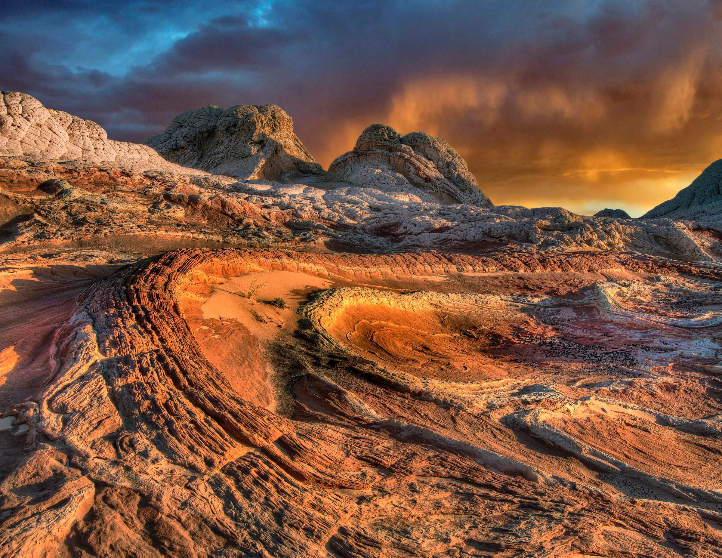
White Pocket looks as though pale stone has risen through a floor of orange ribbons. Rounded domes, tilted layers and closely spaced textures give the eye almost nowhere to rest. It is the place on this list where the approach deserves as much attention as the view.
The formation lies on the Paria Plateau within Vermilion Cliffs National Monument. BLM describes a short path from the parking area to the slickrock, but no developed trail network beyond it. That short walk should not be confused with an easy journey: the access roads contain deep sand and sharp rock, and BLM calls for high-clearance four-wheel drive.
An ordinary rental car is not a sensible default. A vehicle badge alone also says little about the driver’s experience in sand or the rental agreement’s limits. If those questions are unresolved, consider an authorized guide or select a different landscape. BLM itself advises using a guide when you are unsure about the drive.
Rain changes the calculation again. Even maintained House Rock Valley Road can become impassable when wet. Check conditions with the land manager before setting out, carry supplies, and make this a dedicated outing. A photograph of a dry sandstone surface tells you nothing about the road between that surface and the highway.
Sources: White Pocket Trailhead — Bureau of Land Management · Vermilion Cliffs National Monument — BLM
4. Blue Mesa: lilac badlands and trees turned to stone
Blue Mesa supplies a different Arizona palette: muted purple, gray, peach and blue bands across rounded badlands. Petrified wood adds another visual puzzle. These ancient logs are largely quartz, formed as minerals entered buried wood and crystallized within its structure. What resembles a broken tree belongs to a much older world.
Inside Petrified Forest National Park, the one-mile Blue Mesa loop descends among the hills and then climbs back out. NPS describes a paved and gravel surface with a steep grade; most of the route is not suitable for mobility devices. Decide based on the return climb as well as the enticing view downhill.
There is a worthwhile alternative. Blue Mesa’s 3.5-mile road loop has overlooks, so visitors can appreciate the bands without committing to the walking loop. This makes the area useful for a mixed group in which some people want to hike and others prefer viewpoints.
Watch the gate hours. The park currently lists its road as open 8 a.m.–5 p.m. Mountain Standard Time, with Thanksgiving and Christmas closures. A late arrival aimed at a dramatic sunset may miss the visit altogether. Build your day around the park’s schedule, then choose how much of the landscape to explore on foot.
Sources: Walk Blue Mesa Trail — NPS · Places to go at Petrified Forest — NPS · Petrified Forest operating hours — NPS · Petrified wood: mineral replacement — NPS
5. Canyon de Chelly: sheer walls above a living landscape
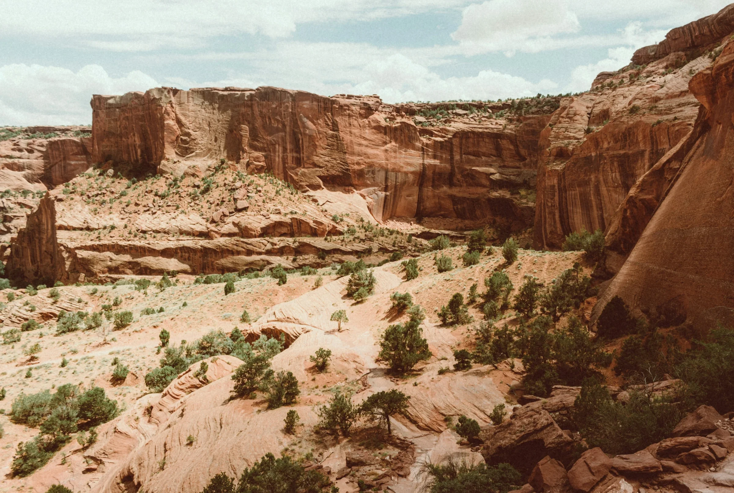
From the rim, Canyon de Chelly combines immense sandstone walls with trees, fields and signs of daily life below. That contrast is central to the place. Diné families continue to live and farm here, and the Navajo Nation and National Park Service work together to manage the monument. This is someone’s home as well as a remarkable view.
A first visit can follow the paved North and South Rim drives and their designated overlooks. There is no entry fee for the scenic drives, and NPS suggests allowing around two hours for each. You can choose one rim instead of rushing both, leaving time to read the interpretation and understand what lies beyond the cliffs.
Going into the canyon is a separate decision. Arrange an authorized guide and the required backcountry permit; registered operators offer different kinds of visits, subject to conditions and restrictions. NPS recommends reservations from March through October.
As checked October 14, 2026, the visitor information page explicitly lists White House Overlook and Trail as closed, even though other park copy still mentions the trail. Do not build an independent hike around the older wording. Follow the current closure notices and stay on the designated paved approaches, particularly after rain.
Sources: Things to do at Canyon de Chelly — NPS · Canyon de Chelly: a living Diné landscape — NPS · Tours of the canyon — NPS · Canyon de Chelly conditions — NPS
6. Monument Valley: isolated towers against an enormous sky
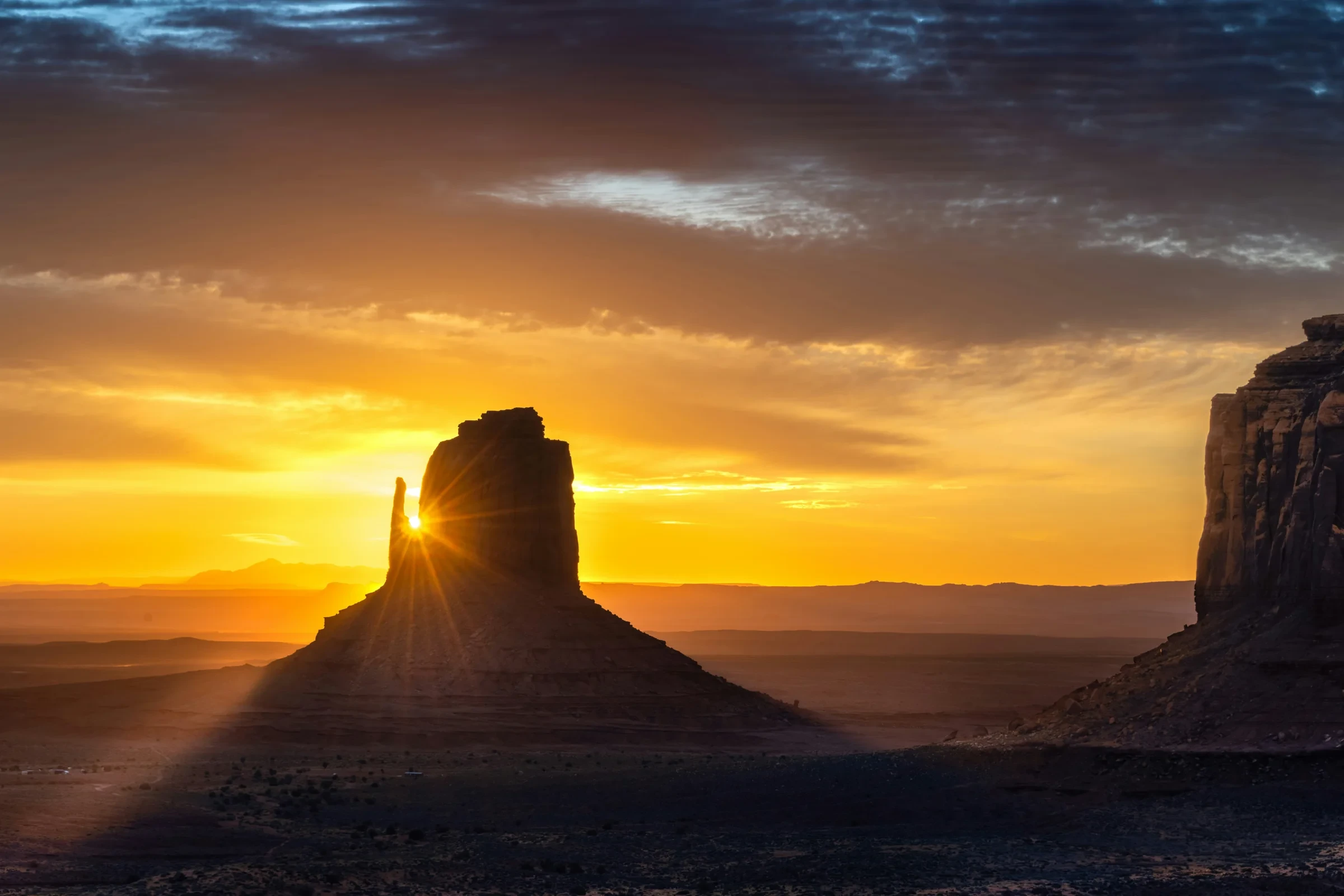
Monument Valley’s buttes have such distinct silhouettes that a single tower can hold an entire composition. The visitor-center view of the Mittens and Merrick Butte is a good place to understand that scale before deciding whether to go farther.
This Navajo Tribal Park spans the Arizona–Utah border. It belongs in an Arizona landscape trip, but describing the entire valley as exclusively Arizona would be misleading. Its admission and access rules are also separate from the national park system.
The 17-mile scenic loop brings you closer to formations, with rough ground and deep sand along the route. Assess the vehicle and current road conditions before committing. An authorized Navajo-guided tour is another way to visit, and restricted locations beyond the designated route require a guide. Entry is not permission to wander across the surrounding land.
For an October 2026 visit, the dated park schedule matters: last entry to the scenic drive is 3:30 p.m. through October 16, then 2:30 p.m. from October 17 under the winter schedule. Viewpoint hours differ from drive access. Reconfirm the applicable hours and local time before departure, especially if a photograph has inspired you to arrive near sunset. Check photography rules with the park or operator; drones are prohibited.
Sources: Monument Valley Navajo Tribal Park — dated operating schedule · Guided tour operators — Navajo Nation Parks · Navajo Nation permits and photography rules
7. Watson Lake: granite islands and their reflections
Watson Lake trades canyon depth for an intimate jumble of rounded granite. The formations of Prescott’s Granite Dells rise beside and out of the water; when the surface is still, reflections double the shapes. The photograph is striking, but the practical appeal is the range of ways to spend time here.
The city places the lake about four miles from downtown Prescott, at 3101 Watson Lake Park Road. You can make a modest visit with a picnic and views, arrange a paddle, or choose a walk. Boating and kayak or canoe rentals are listed among the options, but check the provider’s current operation before relying on equipment being available.
For a less steep walk, look at the nearby Peavine rail trail. The city identifies it as relatively flat, and the local visitor guide describes dirt and gravel rather than a uniformly paved promenade. Pick a suitable out-and-back distance instead of assuming every route among the granite is equally straightforward.
Swimming is prohibited. This is a lake to enjoy from shore or an appropriate boat, not a substitute beach day. City parking is currently $5. October hours run 6 a.m.–10 p.m.; from November 1, the published winter hours become 7 a.m.–6 p.m. That earlier closing time changes an evening plan.

Sources: Watson Lake — City of Prescott · Prescott Peavine Trail — local visitor guide
8. Chiricahua: a forest of volcanic rock columns
Chiricahua National Monument’s pillars crowd the hillsides like a city with no straight streets. Some formations appear to balance on much narrower bases. Unlike the sandstone of several northern stops, these rocks began with volcanic ash and debris that compacted into rhyolite tuff, then fractured and eroded into the shapes visible today.
The eight-mile Bonita Canyon scenic drive leads to Massai Point, where you can look across the formations without choosing a long backcountry hike. A half-mile nature trail adds interpretation; NPS identifies its initial paved section as wheelchair accessible, not the entire loop. That distinction helps visitors choose the part that fits their needs.
Vehicle size is a real planning constraint. Vehicles longer than 24 feet cannot continue beyond the campground toward the upper road, and day-use trailers must be detached at Faraway Ranch. Check the full restrictions before bringing an RV. Admission to the monument is free.
Give this southeastern Arizona stop its own travel time rather than adding it casually to a northern canyon itinerary. Weather can affect the approach as well as the trails, including flooding after heavy rain. The reward is a landscape with a completely different origin and texture, reached by a scenic drive when conditions permit.
Sources: Chiricahua scenic drive and vehicle limits — NPS · Massai Point Overlook — NPS · Chiricahua geologic formations — NPS · Chiricahua alerts and conditions — NPS
9. Tonto Natural Bridge: a stone roof over Pine Creek
Tonto Natural Bridge is impressive because of what is missing: a great opening beneath a broad mass of travertine. The park lists the bridge at 183 feet high. Its history of spring-deposited stone gives it a different character from the sandstone arches visitors may know elsewhere in the Southwest.
Near Payson, the state park offers paved paths above the bridge and four viewpoints. Those views make the scale legible without requiring a descent into the creek bottom. They are also the relevant way to plan a visit right now.
On October 14, 2026, the park’s current notice says Pine Creek, Gowan, Waterfall and Anna Mae trails, plus everything beneath the bridge, are closed because of rain and flooding. The paved walking path on top remains open. No reopening date is stated. A generic trail description or an older photograph beneath the arch does not override that notice.
Normal published park hours are 9 a.m.–5 p.m., with last entry at 4 p.m. Recheck the homepage before making the drive. If walking beneath the bridge is your main reason for going, postpone that plan until the park confirms access; if you want the upper views, judge the visit on that more limited but still worthwhile experience.
Sources: Tonto Natural Bridge — current park notice · Tonto Natural Bridge trails and viewpoints · Tonto Natural Bridge park history — Arizona State Parks
10. The Superstition Mountains: cliffs rising behind the saguaros
The Superstitions offer the most recognizably Sonoran scene in this selection: saguaros across rocky slopes, with a rugged mountain wall behind them. The contrast between upright cactus and broken cliffs makes even a short visit feel visually complete.
Lost Dutchman State Park, near Apache Junction east of Phoenix, provides a practical starting point. The Native Plant Trail introduces desert plants close to the ranger station. For a longer walk, the park lists Treasure Loop at 2.4 miles round trip, with 500 feet of elevation change and a moderate rating. Choose between them according to the day’s heat and your group’s ability.
Do not mistake every trail on the map for a variation on that moderate loop. The Flatiron route is steep, difficult to follow in places and not maintained all the way; the park reserves that advice for experienced hikers and warns against hot-weather attempts. You do not need to climb it to appreciate the mountains.
Day-use gates currently lock at 8 p.m. and reopen at 6 a.m. Plan your return accordingly. Cooler conditions make walking more appealing, while spring wildflowers depend on rainfall rather than the calendar alone. Let the mountain-and-cactus landscape be the promise; a particular bloom or dramatic sky is a bonus.

Sources: Lost Dutchman State Park — hours and visitor information · Lost Dutchman hiking trails — Arizona State Parks
Choose a trip you can enjoy, then check the access
These ten places are a menu, not a sensible single-weekend circuit. Start with the kind of access that suits you. A reserved tour fixes part of your day; a remote sand-road outing needs a separate preparation decision; a scenic drive still has gates, weather and vehicle limits.
For a Page stay, Horseshoe Bend and an Antelope Canyon booking make a coherent pairing. Treat White Pocket as a separate excursion with its own vehicle or guide arrangements. Across northeastern Arizona, Blue Mesa, Canyon de Chelly and Monument Valley can be considered as different stops in a longer road trip, with overnight locations chosen around the route. They are not interchangeable roadside viewpoints.
For residents building shorter outings from central Arizona, choose one of Watson Lake, Tonto Natural Bridge or Lost Dutchman according to where you start and what is open. Chiricahua deserves a southeastern plan of its own. These are editorial planning suggestions, not timed itineraries or promises about driving conditions.
Before leaving, check the relevant land manager and AZ511 for highway conditions. Check the forecast for the destination rather than assuming Phoenix weather applies across the state. Save your reservation instructions and leave room to change plans. A visit that delivers one extraordinary view, comfortably and within the rules, is more satisfying than collecting ten names while racing closing gates.
- Book the required guided visit before arranging the rest of an Antelope Canyon day.
- Match the vehicle and driving experience to White Pocket’s access roads; a short walk at the end does not simplify the approach.
- For Petrified Forest, allow time beyond the roughly one hour NPS budgets just to drive the 28-mile main road.
- Use the October 14 access notes as a starting point, then recheck closures and hours before your own travel date.
Sources: Horseshoe Bend — National Park Service · Upper Antelope sightseeing tour — detailed walking requirements · Vermilion Cliffs National Monument — BLM · Petrified Forest trip itineraries — NPS · Tours of the canyon — NPS · Chiricahua scenic drive and vehicle limits — NPS · AZ511 highway closures, roadwork and weather layers
The details
A few good questions.
Can I visit these places without doing difficult hikes?
Several offer scenic drives or viewpoints, including Blue Mesa, Canyon de Chelly’s rim drives and Massai Point. Tonto Natural Bridge currently permits its upper paved path while the lower trails are closed. Surfaces, distances and gradients differ, so check the specific route instead of treating a viewpoint as automatically accessible to everyone.
Does one national park pass cover the whole list?
No. Horseshoe Bend has municipal parking charges, Navajo Tribal Parks use their own entry and tour arrangements, and Arizona state parks and Watson Lake have separate fees. Check the exact stop’s current charges before travel.
Can I drive a regular rental car to White Pocket?
BLM specifies high-clearance four-wheel drive for the deep sand and rough access. Check your vehicle, rental terms, experience and current conditions. If those do not fit, choose an authorized guided trip or a different destination.
Are these photographs what I will see on the day?
They are credited photographs of the named landscapes, not live condition reports. Light, water, weather and access change. Follow current park notices and operator instructions even when an older photograph shows an activity or viewpoint you cannot currently reach.
Behind the story
Sources & further reading.31 sources behind this story
Research reviewed October 14, 2026. Check the linked providers for updates before travel.
Researched and written with AI, with automated editorial review. Read how we check our stories.
- Horseshoe Bend — National Park ServiceChecked 2026-10-14
- White Pocket Trailhead — Bureau of Land ManagementChecked 2026-10-14
- Horseshoe Bend visitor information — City of PageChecked 2026-10-14
- Things to do at Canyon de Chelly — NPSChecked 2026-10-14
- Walk Blue Mesa Trail — NPSChecked 2026-10-14
- Watson Lake — City of PrescottChecked 2026-10-14
- Chiricahua scenic drive and vehicle limits — NPSChecked 2026-10-14
- Places to go at Petrified Forest — NPSChecked 2026-10-14
- Petrified Forest operating hours — NPSChecked 2026-10-14
- Canyon de Chelly conditions — NPSChecked 2026-10-14
- Massai Point Overlook — NPSChecked 2026-10-14
- Tonto Natural Bridge — current park noticeChecked 2026-10-14
- Tonto Natural Bridge trails and viewpointsChecked 2026-10-14
- Vermilion Cliffs National Monument — BLMChecked 2026-10-14
- Chiricahua geologic formations — NPSChecked 2026-10-14
- Prescott Peavine Trail — local visitor guideChecked 2026-10-14
- Canyon de Chelly: a living Diné landscape — NPSChecked 2026-10-14
- Lost Dutchman State Park — hours and visitor informationChecked 2026-10-14
- Petrified Forest trip itineraries — NPSChecked 2026-10-14
- Chiricahua alerts and conditions — NPSChecked 2026-10-14
- Petrified wood: mineral replacement — NPSChecked 2026-10-14
- Lost Dutchman hiking trails — Arizona State ParksChecked 2026-10-14
- AZ511 highway closures, roadwork and weather layersChecked 2026-10-14
- Antelope Canyon Tours — visitor logisticsChecked 2026-10-14
- Tours of the canyon — NPSChecked 2026-10-14
- Tonto Natural Bridge park history — Arizona State ParksChecked 2026-10-14
- Upper Antelope sightseeing tour — detailed walking requirementsChecked 2026-10-14
Your next somewhere.
U.S. travel stories with sources you can follow and places worth making time for.
Our editorial approachExplore destinationsShare a little inspiration