Chicago, Illinois
Chicago’s Skyline Has a Story. Follow the River to Find It.
Start at the Michigan Avenue bridge, follow the water west and discover why Chicago’s buildings look the way they do. Add an architecture cruise if you want the wider story.

At Michigan Avenue, Chicago offers an unusually good place to learn how to look at a city. A white clock tower rises on one bank; a working bridge crosses the water below it. Farther along, concrete balconies curl around twin towers, and glass follows a bend in the river. These buildings were made for different ambitions: selling, trading, living, moving. Follow the water and those ambitions become visible. This is a river afternoon built around a few things worth noticing, with an optional architecture cruise to connect the larger picture.
At a glance
- The route
- Begin at DuSable Bridge on Michigan Avenue, then follow the south-bank Riverwalk west toward the confluence and Lake Street. This is part of the full 1.25-mile Riverwalk.
- Time to allow
- Our suggestion: a half-day for the walk, pauses and an optional 90-minute cruise. Allow the operator’s requested 30 minutes before boarding.
- Research checked
- October 16–17, 2026. See the transport section for current bridge work and station closures.
Begin with the bridge
Start on the public sidewalk at the south end of DuSable Bridge, also called the Michigan Avenue Bridge. Before heading down to the water, take in the relationship between the street and the river. The bridge carries people across; boats need passage along. Chicago’s architecture has always had to negotiate both directions.
The bridge opened in 1920. Its trunnion bascule design allows the roadway to rotate upward around fixed horizontal pivots. The mechanism solves a practical problem with an unexpectedly theatrical result: a piece of the street can rise into the air. A bridge lift is a separate event, however, not something to expect every time a sightseeing boat passes underneath.
For a closer look, the McCormick Bridgehouse & Chicago River Museum occupies the southwest bridgehouse at river level. Inside, machinery and exhibits connect the bridge to the wider history of the waterway. It is an appealing optional stop if engineering interests you, rather than a compulsory ticket on this walk.
The museum normally opens Wednesday–Sunday, 10 a.m.–5 p.m., during its May–October season. General admission is a pay-what-you-can donation; guided tours and bridge-lift viewings are separate offerings. Check the calendar before relying on a particular date. The historic building has narrow stairs and no elevator; ask about the first-floor and gear-room alternative if climbing does not suit you.
The river’s biggest story is partly invisible
The water in front of you once carried the consequences of a rapidly industrializing city. Sewage and industrial waste entered a river that flowed toward Lake Michigan, Chicago’s drinking-water source. The waterway that helped the city prosper also threatened the people living beside it.
In 1900, the new Chicago Sanitary and Ship Canal reversed the river’s flow away from the lake. That engineering intervention is central to Chicago’s story, but it needs its second sentence: sending polluted water downstream did not make the pollution disappear. Sewage treatment and subsequent environmental work were still necessary. The Metropolitan Water Reclamation District’s history traces both the canal project and the long development of treatment infrastructure.
Keep that history in mind as you reach the promenade. The change from an industrial edge to a place for sitting beside the water was neither automatic nor one designer’s single act. The Riverwalk developed in phases, with later connections allowing people to pass beneath the street bridges instead of repeatedly climbing back to road level.
That is one reason this route is rewarding. You can look up at individual buildings, then look down at the public ground that makes the view possible. Both are designed environments. The benches, paths and planted edges belong in the architectural story as much as the towers.
Decide whether to take the story onto the water
A cruise adds a different scale of understanding. On foot, you can stop and study a facade; from a boat, the sequence of buildings, bridges and river branches becomes easier to grasp. Neither replaces the other. If this is your first Chicago visit and architecture is a priority, our recommendation is to combine a cruise with a shorter, unhurried walk.
One clearly defined option is the Chicago Architecture Center River Cruise aboard First Lady. Its 90-minute tour is narrated by trained volunteer CAC docents and normally operates March–November. The published route follows all three branches of the Chicago River, subject to changes; it does not go onto Lake Michigan. Other operators and products have different routes, so book the experience you actually want rather than assuming every river ticket is equivalent.
Reserve for your date and check the final price, departure time and terms. First Lady asks the entire party to arrive 30 minutes early. Its tickets are nonrefundable and nonexchangeable, and cruises ordinarily run in rain. All ages need a ticket for this architecture product. The operator’s separate sightseeing cruises have different child-ticket policies.
The GPS address is 112 E. Wacker Drive, but the dock is down at river level, east of Michigan Avenue, marked by a black awning. The Chicago Architecture Center at 111 E. Wacker is the exhibition venue across the street. Treat those as two distinct destinations when planning your arrival.
At Michigan Avenue, buildings become advertisements
Look across the river toward the Wrigley Building. Its paired white towers and clock make an immediate impression, even among much taller neighbors. Designed by Graham, Anderson, Probst & White as the chewing-gum company’s headquarters, it shows how an office building can give a brand a place in the city’s imagination.
Notice the surface as well as the silhouette. The Chicago Architecture Center describes six shades of terracotta, graduating lighter toward the top. The apparent simplicity of a white building comes from a carefully adjusted material palette. You can appreciate that idea without identifying every decorative detail or entering the building.
Nearby Tribune Tower offers a different kind of authority. In 1922, the newspaper’s design competition drew more than 260 entries from 23 countries. John Mead Howells and Raymond Hood won with a Gothic Revival tower whose upper reaches borrow the visual language of medieval architecture. For a modern newspaper, an old architectural vocabulary could communicate permanence and prestige.
Compare those choices from the river crossing and surrounding public sidewalks. One company presented itself through a luminous clock tower; another reached for Gothic grandeur. The point is not to memorize styles. It is to ask what the people paying for a building wanted everyone else to see. This part of the outing needs no lobby access or observation-deck reservation.
Marina City asks a different question: could downtown be home?
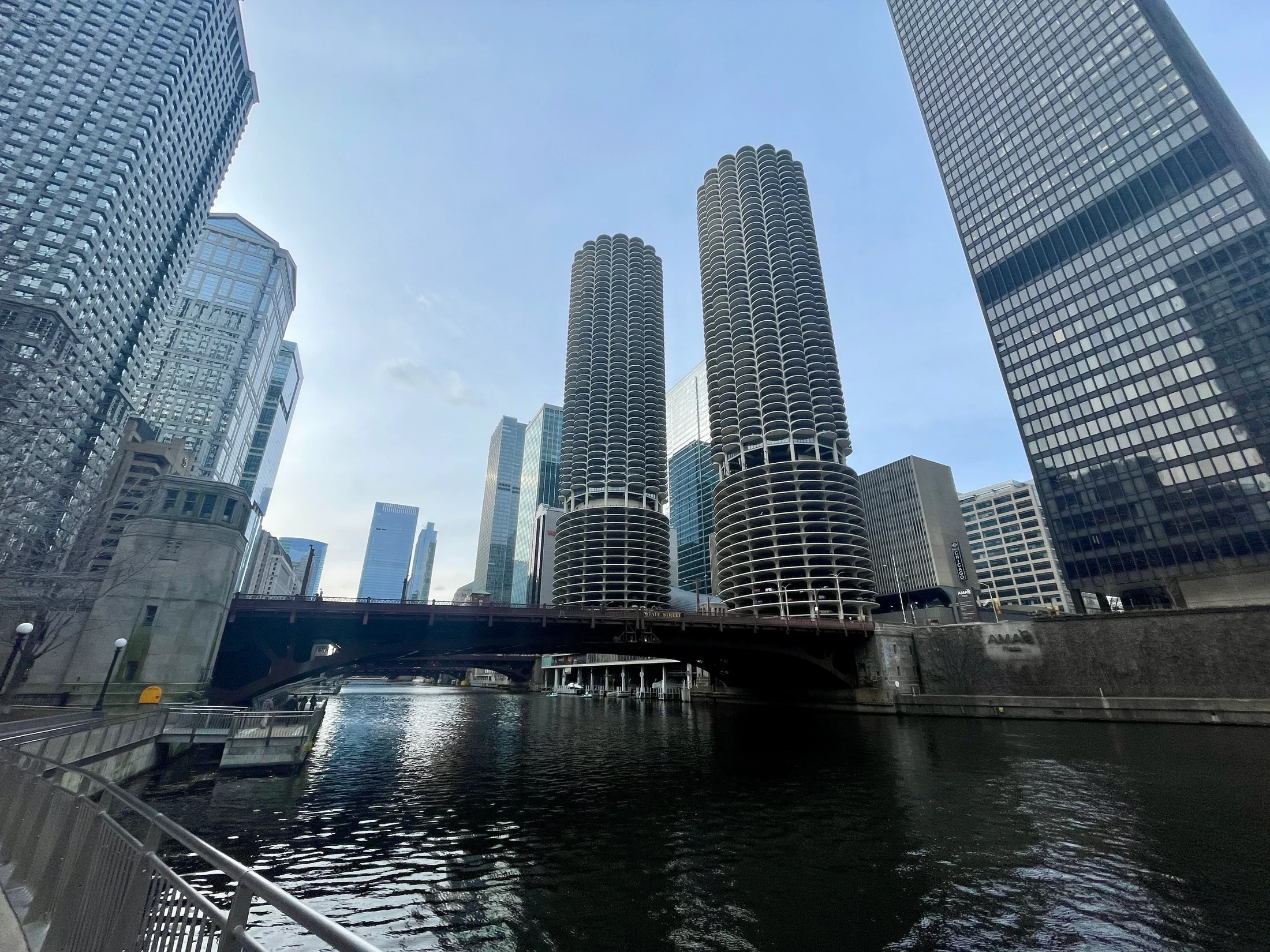
Head west along the south-bank Riverwalk toward State Street. Across the water, Marina City’s round towers interrupt the rows of flat office facades. Their repeating balconies give the concrete a petal-like edge; the open parking levels below make another part of daily life unusually visible.
Architect Bertrand Goldberg’s project proposed more than an arresting skyline shape. It combined apartments with work, entertainment, shopping, parking and a marina, imagining downtown as a place where residents could organize much of their everyday life. In the Chicago Architecture Center’s account, the complex was a deliberate argument for urban living at a time when suburban development exerted a powerful pull.
That makes Marina City a useful contrast with the buildings near Michigan Avenue. A headquarters announces an institution. A mixed-use complex has to accommodate the repeated routines of people coming home, buying things, meeting friends and moving around. The architecture expresses a different set of priorities.
Stay on the public river path to study that contrast. Let the eye move between balcony, parking deck and water rather than searching only for the photograph in which the towers stand alone. The surrounding buildings help explain why Goldberg’s curved forms remain so distinctive. You are looking at a proposal for city life as well as a recognizable Chicago landmark.
The Riverwalk itself deserves a stop
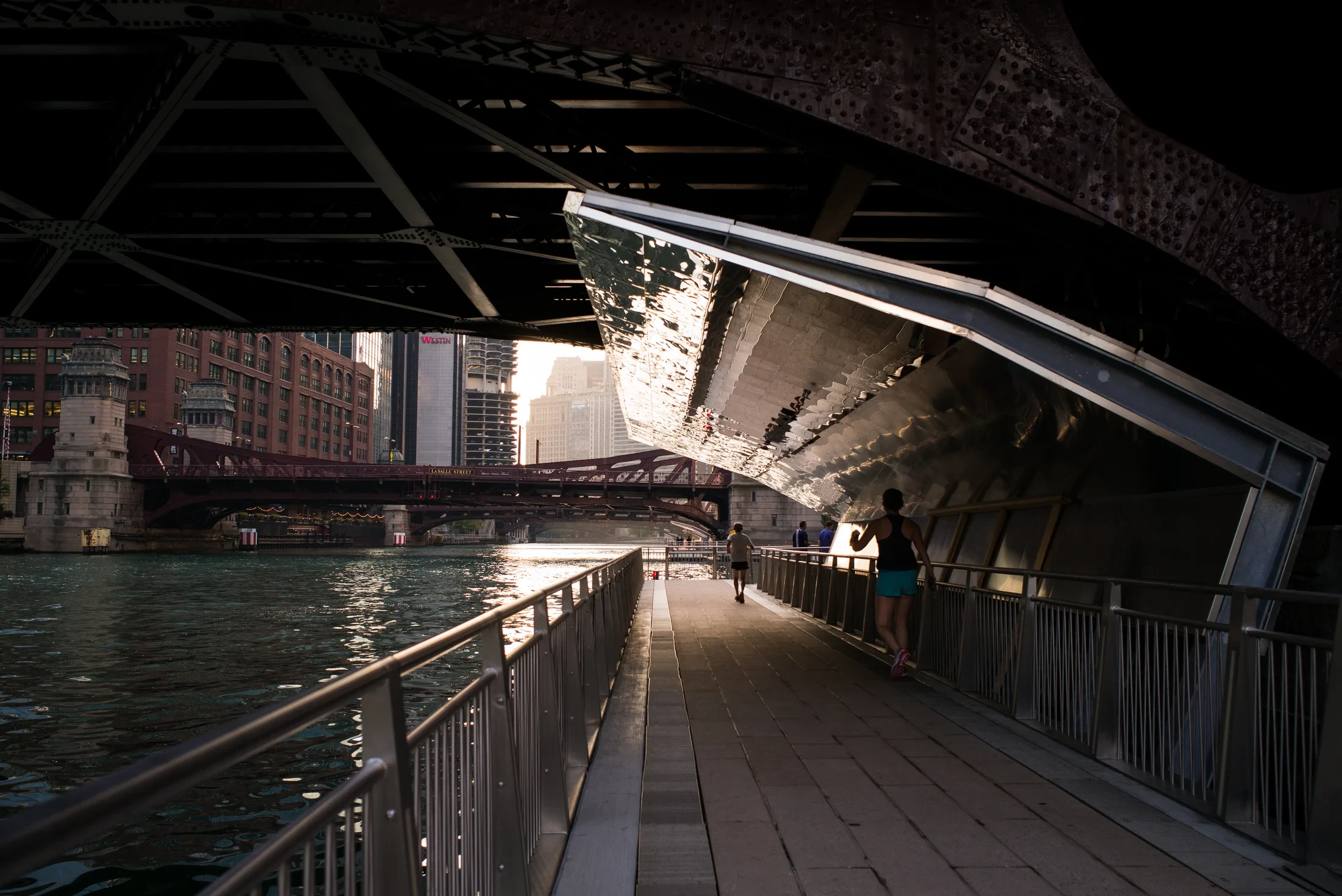
Continue west and pay attention to changes underfoot. Between the bridges, the Riverwalk opens into spaces with different proportions and uses. A narrow connecting passage gives way to seating; terraces make room for people to linger. The designers treated the waterfront as a sequence of places rather than a single strip of pavement.
At the River Theater, between Clark and LaSalle, broad seating steps intersect a gently sloping path connecting upper Wacker Drive with the river. Ross Barney Architects describes the design as both circulation and a gathering place. That double purpose is easy to appreciate: the route down becomes somewhere to remain.
The larger Riverwalk project involved Ross Barney Architects, Sasaki and other collaborators, working within a confined river edge and the needs of a navigable channel. Connections beneath the bridges are particularly important. They allow the walk to feel continuous even while cars and pedestrians cross overhead.
Choose a place to pause here. Our suggestion is to spend a few minutes following the different kinds of movement: people crossing a bridge, boats passing beneath it, someone descending from street level. The city is doing several things in the same small space. There is no ticket or scheduled performance required to see that.
The city lists the Riverwalk as free and open 6 a.m.–11 p.m. Food and drink concessions have their own, often seasonal schedules. Bring your own plan for a break instead of assuming every waterside business operates whenever the path is open.
.jpg)
Toward the bend, commerce changes shape
Farther west, the Merchandise Mart stretches along the opposite bank. Opened in 1930 as a wholesale center, it gathered showrooms and goods under an enormous roof. Where Marina City stacks domestic life vertically, the Mart makes the scale of buying and selling visible.
Look for its strong upright lines between recessed windows. Those Art Deco details organize a building that could otherwise read as a single wall. You do not have to venture inside to understand its original ambition: bringing a great deal of commercial activity together in one place.
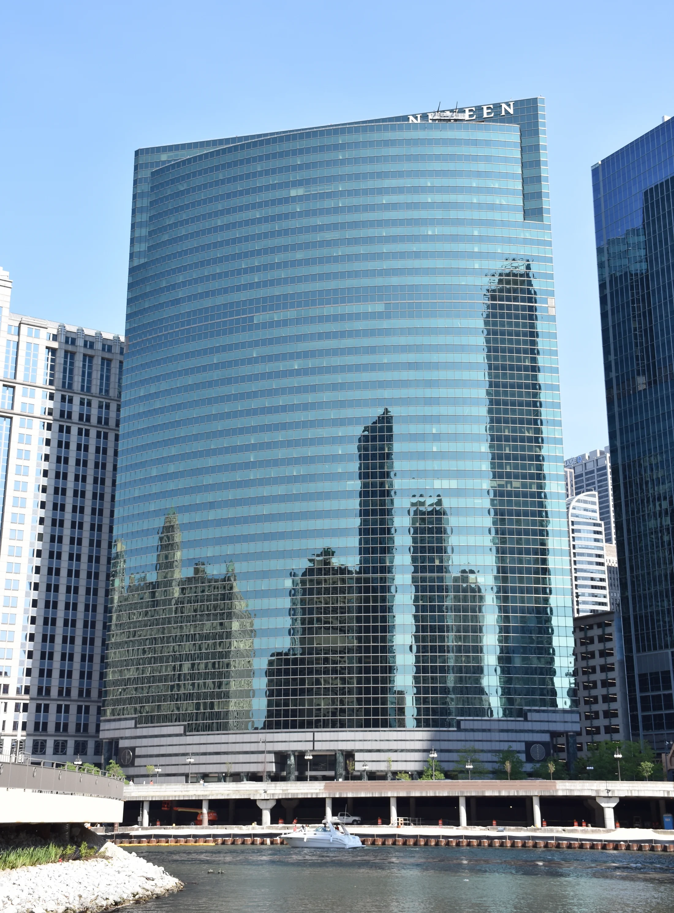
Near the river’s branching point, shift attention to 333 West Wacker. Kohn Pedersen Fox gave its river-facing side a broad curve of reflective glass. The bend in the waterway becomes part of the building’s form, while the street side responds to the downtown grid. The relationship is especially satisfying after a walk spent noticing how earlier buildings claimed attention through ornament and bulk.
If you take the cruise, 150 North Riverside adds another useful comparison. Its narrow base widens into larger upper floors, an engineering response to a site constrained by railway tracks, the river and other requirements. It makes the pressure of the ground beneath a skyscraper visible in the shape above.
The confluence is a natural place to finish the architectural story. It also marks the point to resist turning a manageable afternoon into an attempt to cover every waterfront development. The city's continuous main Riverwalk extends to Lake Street; other riverfront paths should not be assumed to form one uninterrupted route farther south. During bridge work, follow posted pedestrian restrictions near Lake Street and finish earlier if the western end is blocked.

Adjust the afternoon for weather and access
The Chicago Architecture Center is a useful indoor alternative when prolonged time beside the river loses its appeal. At 111 E. Wacker Drive, the Chicago City Model Experience lets you view the city at a scale that is impossible from a sidewalk. It works as a starting point, too: see the larger pattern, then go outside to find a few of its pieces.
Current center hours are Sunday–Thursday, 10 a.m.–5 p.m., and Friday–Saturday, 10 a.m.–7 p.m.; last entry is one hour before closing. Check current exhibitions and admission details for your date. A particular gallery installation or cruise-ticket package may change what is included.
For a stair-free approach to the First Lady dock, the operator directs visitors to the ramp at State Street and Wacker Drive, then east along the Riverwalk beneath Michigan Avenue. Build in time for that route instead of using the nearest stairway as your arrival plan.
Dock access and boat access require separate checks. First Lady permits manual wheelchairs aboard but does not permit electric wheelchairs or mobility scooters; some passengers may be able to transfer to a provided manual chair with their own assistance. Vessel thresholds and stairs to the upper deck remain important. Contact the operator about the specific boat and your needs before purchasing. A step-free riverside path is not a promise of unrestricted movement throughout a boat.
Put the pieces together without racing the clock
For a walking afternoon, start at DuSable Bridge, consider the Bridgehouse Museum if it is open, then follow the south bank west past Marina City, the River Theater and the Merchandise Mart views toward the bend. Leave room for a meal or an indoor stop. Half a day is our editorial planning allowance, not a measured walking duration.
For a cruise day, make the booked departure the fixed point. Allow the requested early arrival, take the 90-minute cruise, then walk only as far as your interest and energy take you. You will recognize buildings from the narration and can give a few of them a second look. There is no need to repeat the boat’s entire route on land.
Transport deserves a final check. As of October 17, 2026, the State/Lake elevated station is closed for reconstruction into 2029. Lake on the Red Line is a separate subway station. Lake Street Bridge work also changes Green and Pink Line service through October 25, with completion scheduled for early October 26; additional Loop elevated service suspensions are scheduled October 24–26. Use CTA’s current alerts for your actual journey, even when an attraction’s directions still list the usual stations.
By the end, the skyline should feel less anonymous. The white tower, the concrete balconies and the curved glass each answer a different question. The river gives you enough distance to see the answers—and a public place from which to keep looking.
The details
A few good questions.
Do I need a boat ticket to enjoy Chicago’s architecture?
No. This walk uses public sidewalks and the free Riverwalk. A cruise adds narration and views along more of the river, while the walk lets you stop where you choose.
How long is the Chicago Riverwalk?
The city describes the full path from Lake Street to the lakefront as 1.25 miles. The Michigan Avenue-to-confluence walk suggested here covers part of it, with optional museum and cruise stops.
Does the CAC First Lady architecture cruise go onto Lake Michigan?
No. The selected 90-minute architecture product stays on the Chicago River. Check the operator’s other offerings if time on the lake is your priority.
Can I do this in winter?
Plan around a shorter outdoor walk and indoor time at the Chicago Architecture Center, checking weather and current access. The selected cruise normally runs March–November, and the Bridgehouse Museum normally operates May–October.
Behind the story
Sources & further reading.33 sources behind this story
Research reviewed October 17, 2026. Check the linked providers for updates before travel.
Researched and written with AI, with automated editorial review. Read how we check our stories.
- Current rail service alerts | CTAChecked 2026-10-17
- Lake Street Bridge work and train diversions | CTAChecked 2026-10-17
- Chicago Riverwalk: access and hours | City of ChicagoChecked 2026-10-16
- River Cruise FAQ | Chicago Architecture CenterChecked 2026-10-17
- Accessibility & Safety | Chicago Architecture CenterChecked 2026-10-16
- Accessibility | First LadyChecked 2026-10-17
- CAC architecture cruise: route and tickets | First LadyChecked 2026-10-17
- First Lady: dock location and directionsChecked 2026-10-16
- Marina City | Chicago Architecture CenterChecked 2026-10-16
- 333 West Wacker | Chicago Architecture CenterChecked 2026-10-16
- Wrigley Building | Chicago Architecture CenterChecked 2026-10-16
- Tribune Tower | Chicago Architecture CenterChecked 2026-10-16
- Merchandise Mart | Chicago Architecture CenterChecked 2026-10-16
- How does 150 N. Riverside stay standing? | Chicago Architecture CenterChecked 2026-10-16
- Visit the Center | Chicago Architecture CenterChecked 2026-10-17
- Exhibitions | Chicago Architecture CenterChecked 2026-10-17
- Chicago Riverwalk | Chicago Architecture CenterChecked 2026-10-16
- Trunnion Bascule Bridge | Chicago Architecture CenterChecked 2026-10-16
- Chicago Riverwalk | Ross Barney ArchitectsChecked 2026-10-16
- The River Theater: An Interface of Geometries | Ross Barney ArchitectsChecked 2026-10-16
- A History of Protecting Our Water Environment | MWRDChecked 2026-10-16
- Bridgehouse Museum: visiting information | Friends of the Chicago RiverChecked 2026-10-17
- Bridgehouse Museum: 2026 tours and accessChecked 2026-10-16
- Chicago Riverwalk in Chicago | Choose ChicagoChecked 2026-10-16
- Lake (Red Line station) Station Information - CTAChecked 2026-10-16
- MarinaCity2024-02-16.jpg — photograph and licenseChecked 2026-10-16
- Photograph license: CC0Checked 2026-10-16
- Chicago Riverwalk (43545448735).jpg — photograph and licenseChecked 2026-10-16
- Photograph license: CC BY 2.0Checked 2026-10-16
- 333 Wacker Drive, Chicago in May 2016.jpg — photograph and licenseChecked 2026-10-16
- Photograph license: CC BY-SA 4.0Checked 2026-10-16
- CDOT and CTA Prepare for Temporary Lake Street Bridge Closure for Major Replacement Work - Press Releases - News - CTAChecked 2026-10-16
- Chicago Riverwalk: design and engineering | SasakiChecked 2026-10-16
Your next somewhere.
U.S. travel stories with sources you can follow and places worth making time for.
Our editorial approachExplore destinationsShare a little inspiration