Ajo, Arizona
Don’t Rush Through Ajo: A Two-Day Organ Pipe Weekend
Give Ajo’s plaza and creative community a day of their own, then head south for Organ Pipe’s cactus landscapes. A practical two-day plan, with the choices that keep it unhurried.
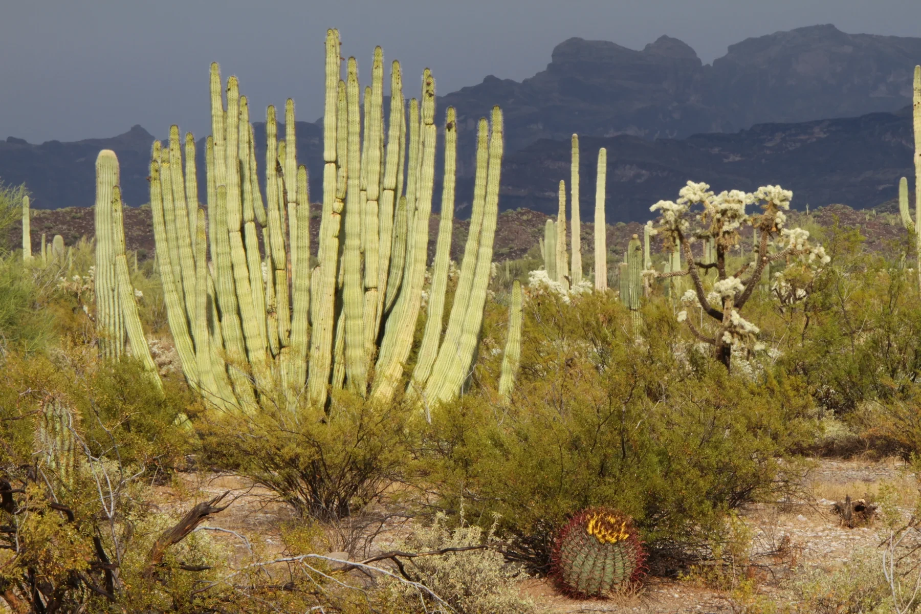

The usual temptation in Ajo is to keep going. Organ Pipe Cactus National Monument lies farther south on State Route 85, and the mountains and columnar cacti are a persuasive destination. But the town’s arcades, old school buildings and public art deserve more than a photograph through the car window. A better weekend gives each place room: a first day around Ajo’s plaza, history and creative community, followed by a park day built around a scenic drive and a modest walk. Arrive Friday evening if you want two full days without combining the journey to Ajo with the town visit. One night can work too, provided you accept a shorter first day. This is a suggested itinerary, not a package or a claim that every door will be open. Details were checked October 23, 2026. The seasonal market has not started yet, the park’s visitor-center hours change in November, and road closures deserve a fresh look before you leave.
At a glance
- Suggested time
- Two days; arrive Friday evening for two full days, or shorten the first day for a one-night trip.
- Town-to-park planning
- Allow for roughly 33–34 miles from Ajo to the main visitor-center and scenic-drive area, beyond the park boundary.
- Park entry
- Standard private vehicle: $25 for seven consecutive days; camping is separate. Card payment.
- October and November
- Visitor center: 8 a.m.–4 p.m. through October; 9 a.m.–5 p.m. from November. Ajo’s seasonal mercado starts November 14, 2026.
Start with the plaza—and notice what it was built to do
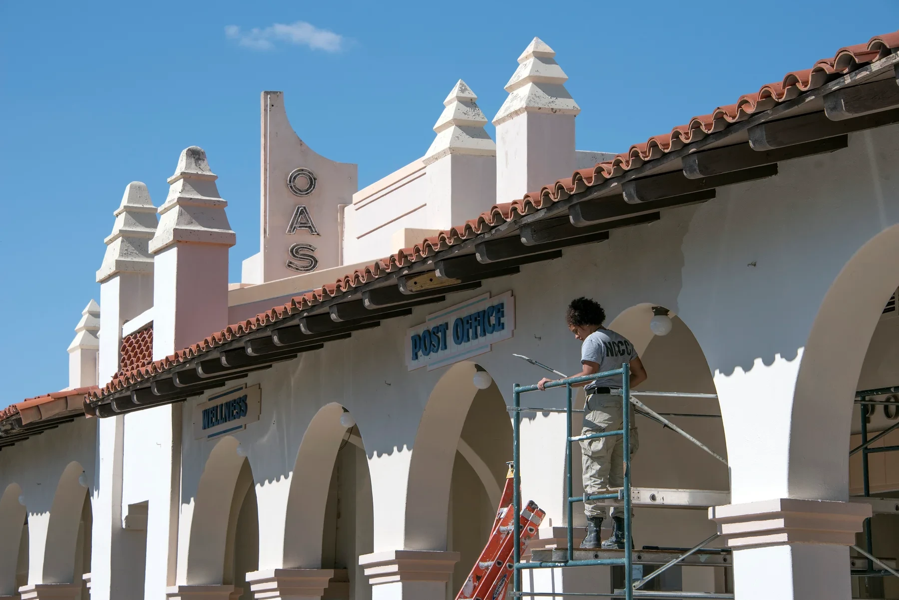
Ajo’s center makes a strong first impression because it was designed to. White arcades frame a central park, the former railway depot anchors the composition, and the Curley School stands along the town’s architectural axis. Instead of treating those buildings as separate photo stops, spend a little time looking at how they face one another. The view helps explain a company town whose public spaces were planned as carefully as its industrial operations.
Begin at the depot, which now houses the chamber of commerce and visitor center. When it is open, ask for current local information and the public-art route. Then walk the plaza at a pace that leaves time for a gallery or coffee. The plaza’s own directory lists Oasis Coffee, the Art Under the Arches cooperative gallery, and Fat Cactus Pizza and Arcade. These are useful starting points for planning a break, but the directory does not establish their daily opening hours. Check the business you actually want before building lunch or dinner around it.
There is pleasure in this being an ordinary working town center as well as a historic one. A post office, library and community organizations share the area with visitor businesses. Leave entrances and workspaces clear, and give the place more attention than a quick circuit for photographs. The best first-hour plan is deliberately loose: orient yourself, get the local information, then follow whichever public-facing stop is open and interests you.
Look beyond the handsome company-town façade
The architecture is only part of Ajo’s history. Pima County dates the beginnings of the present town layout to 1916, as large-scale copper mining developed. The town remained largely company-owned until the mine closed in 1985. That explains why industry and civic design are so closely connected here, but it should not turn the visit into a nostalgic story about an ideal company town.
The National Endowment for the Arts’ account of Ajo’s redevelopment describes the segregated communities of Indian Village and Mexican Town, both of which no longer exist. KJZZ’s reporting includes residents’ memories of those divisions and the complicated feelings attached to the school. The International Sonoran Desert Alliance also explicitly places segregation and extraction within its account of the town’s built heritage. Reading that context changes what the attractive plaza represents: beauty and unequal opportunity existed together.
For a local-history stop, the Ajo Historical Society Museum describes its focus as families, culture, industry and mining. It is volunteer-supported, so confirm that it will be open for your visit; its homepage did not provide a dependable daily schedule when checked. Make it a planned stop only after confirmation, rather than leaving it until the last hour of the day.
The Cornelia mine overlook appears in Arizona’s tourism guidance, but this itinerary does not depend on access to it. A viewpoint is not permission to enter mine property, and current overlook arrangements were not independently confirmed. You can give the mining story serious attention through the town, museum and published local history without improvising an industrial-site visit.

Follow public art, while remembering that artists live here
The Curley School gives the weekend its clearest connection between old buildings and present-day life. ISDA converted the main school building and its J-Wing into affordable live-work apartments. This is residential space, so approach it as a neighborhood landmark rather than an attraction whose rooms are automatically open to visitors. Enjoy the architecture from public areas and enter studios only when there is an invitation or advertised opening.
For a more reliable art outing, use ISDA’s Ajo Art self-guided tour and brochure as a starting point. Its survey gathers public-facing work around town, with most of the listed art accessible to the public. That qualification matters: follow the route’s access information and signs instead of assuming that every interesting object is on public land. The plaza cooperative offers another way to see work by artists from the area without needing a private studio visit.
Artists Alley and murals around the center also feature in the Sonoran Desert Inn’s current visitor guidance. Allow time to read labels and look at individual works; this is more rewarding than trying to collect a fixed number of murals. ISDA’s cultural work includes projects remembering Indian Village and Mexican Town, so public art can carry local memory as well as brighten a wall.
If you are visiting later in the season, the inn’s October announcement says the Ajo Artisans Mercado returns to the plaza on Saturday, November 14, 2026, with Saturday hours of 9 a.m.–1 p.m. through mid-May. It is not an option for an October weekend. Check the current announcement again near your travel date, and leave the town plan flexible enough to work without the market.
Choose a town room or a park campsite for a reason
An Ajo room makes the most sense if you want to spend the first day in town, have dinner there and leave the unpacking alone. The Sonoran Desert Inn and Conference Center occupies former school space on the Curley campus. Its 22 rooms include private bathrooms and air-conditioning, with kitchenettes in some room types. The operator deliberately leaves televisions out, while providing Wi-Fi. That is a useful distinction if your idea of an evening is reading or talking rather than channel-surfing.
Book the actual room type that suits you, especially if you need a kitchenette or specific access features. The property lists accessible queen and two-queen options, but a label alone cannot answer every mobility question. Contact the inn about the room and route you need. Rates, availability and booking terms should come from the current reservation, not a standing price quoted in a travel article.
Camping changes the balance of the trip. Twin Peaks Campground puts you close to the park’s visitor center and trails. NPS lists running-water restrooms, some solar-heated showers and a dump station with potable water, but no electrical, water or sewer hookups at the sites. Its standard camping fee is currently $20 per night, separate from park entry; reservations are made through Recreation.gov, from the same day up to six months ahead.
Alamo Canyon is a more basic alternative with four tent sites, a vault toilet and no water. It is not a substitute for a developed campground if those missing facilities matter to you. For this two-day plan, choose one overnight base rather than moving accommodation just to sample both styles.
Make the visitor center the beginning of your park day
On the second morning, follow SR 85 south from Ajo. Plan around the Kris Eggle Visitor Center, not simply the northern boundary of Organ Pipe. Arizona Highways places the Ajo Mountain Drive turn roughly 33 miles south of Ajo, across the highway from the visitor center; NPS lists the Ajo chamber about 34 miles from the park’s visitor-center area. The park is a substantial landscape, and reaching its boundary does not mean you have reached the day’s main stop.
The visitor center is the place to check road conditions, get orientation and choose a walk that fits the weather and your group. Its published schedule is 8 a.m.–4 p.m. from May through October, changing to 9 a.m.–5 p.m. from November through April. It closes on Thanksgiving and Christmas. The monument’s general 24-hour access does not mean the information desk is always staffed or that every road is open.
The standard private-vehicle entrance fee is $25, valid for seven consecutive days; NPS takes credit or debit cards rather than cash for fee payments. Camping costs extra. Carry your lunch, drinking water and any other essentials before starting the scenic loop. It has no water supply, and a short mileage figure is a poor reason to leave supplies behind.
Current closures are an important part of the route choice. As checked October 23, NPS lists construction-related closures on roads near the international boundary, including Camino de Dos Republicas and Grey’s Ranch Road, while South Puerto Blanco Drive remains open with possible construction delays. This plan does not add a border-road detour or promise access to Quitobaquito. Check the linked alerts and ask a ranger about the specific road you intend to use that day.
Give Ajo Mountain Drive its own part of the day
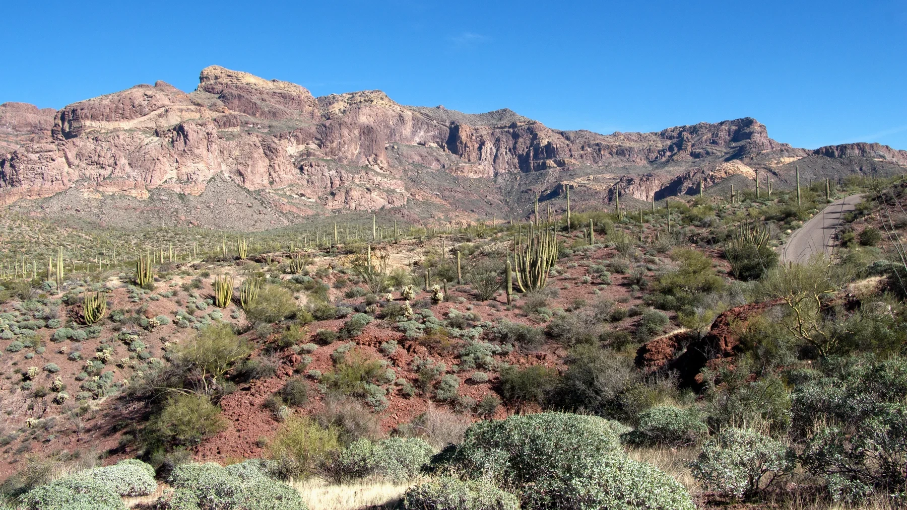
Ajo Mountain Drive is the main landscape outing in this plan: a 21-mile loop of mostly graded dirt road, with short paved stretches and changing views of cacti and mountains. NPS estimates about two hours for the drive alone and two to five hours with stops. Budget for the stops. Otherwise, the trip becomes a slow road you are trying to finish instead of a landscape you have time to notice.
The official description says passenger cars can manage the route cautiously under suitable conditions, but that is not a guarantee about today’s surface or your vehicle. Rain and washouts change the decision. Check with the visitor center, and check your rental agreement if applicable. NPS prohibits trailers, buses and RVs longer than 25 feet on the loop. If the vehicle or road is unsuitable, keep the day around the visitor center and an appropriate short trail instead of testing the limit.
The pleasure of the drive is partly botanical. Organ pipe cacti branch in clusters from near the base, making a very different shape from the familiar branching saguaro. NPS’s species account explains that organ pipes are sensitive to frost and commonly occupy warmer, south-facing slopes. Looking for those differences gives you something to do with the view beyond simply calling it a cactus forest.
There is geology to notice too. The park’s interpretation at stop 9 describes the volcanic layers of the Ajo Mountains: darker rhyolite formed from lava and lighter tuff from volcanic ash. You do not need to identify every layer to appreciate how the vegetation and rock change along the route. Use established pullouts, keep the road clear and leave time for the picnic you packed. Return without making the drive compete with a second long excursion.

Choose a short walk that matches the day
A short walk can add more to this weekend than an ambitious hike squeezed in after the loop. Start with the visitor-center Nature Trail if you want an introduction: NPS lists it as a 0.1-mile round trip on brick, described as accessible, with interpretive exhibits and a pond holding Quitobaquito pupfish. It is a small route with a clear purpose, especially useful when the temperature or your available energy calls for restraint.
For more time among the plants, the Desert View Trail is a 1.2-mile loop near Twin Peaks Campground, with benches and interpretation. Treat its distance separately from its surface and exposure; a modest mileage does not make every desert trail suitable for every person. Ask about current conditions and select it only if it suits your group.
Along Ajo Mountain Drive, Arch Canyon offers a different choice. The maintained trail is listed as 1.2 miles round trip. The unmaintained continuation toward the arch is a separate, more demanding proposition, not the natural next step in an easy walk. There is no need to turn a short canyon visit into a scramble to make the outing count.
Stay on the established route even when a nearby cactus looks like a better photographic foreground. Biological soil crusts can look inconspicuous in this desert, yet they help stabilize soil and can be damaged by footsteps. Give plants and wildlife space, carry water, and adjust activity to heat rather than to the timetable you hoped to follow.
Let the season set the pace
This is most naturally a cooler-season weekend. NPS describes autumn as the transition out of the monsoon period, with winter bringing milder days and potentially cold nights. That is seasonal context, not a forecast. Check the actual weather before choosing the length and timing of outdoor activities, and pack a layer for an evening that may feel very different from the afternoon.
Winter also changes what is available. The park’s ranger-program page describes a December-to-mid-April season; an October visitor should not assume that the regular winter program schedule is already running. Even in season, staffing, weather and road conditions can change individual programs. Consult the current calendar rather than reserving a whole afternoon for an unspecified talk.
Download the route information before leaving town. NPS warns that mobile reception can be patchy within the monument, although service and public Wi-Fi are available at the visitor center. Carry extra water in the vehicle, tell someone your planned route and return time, and use the park’s current guidance for conditions. Those preparations make it easier to keep the day simple when a road or hike needs to change.
The two days do not need a grand finale. An afternoon with Ajo’s public art and a second day noticing the differences among desert plants already make a coherent trip. If you want another kind of Arizona town weekend, compare the small-town guide linked below; for a separate southwestern Arizona history outing, the Yuma riverfront guide offers a different focus. Give each destination its own time instead of stretching this weekend into a statewide circuit.
The details
A few good questions.
Can I do Ajo and Organ Pipe in one day?
You can choose a shorter visit, but this plan gives town and park separate days. Ajo Mountain Drive alone is estimated by NPS at about two hours, or two to five with stops, before the road journey and any town visit.
Do I need four-wheel drive for Ajo Mountain Drive?
NPS describes the graded loop as manageable cautiously in passenger cars under suitable conditions. Ask a ranger about the current surface, consider your vehicle and rental terms, and do not treat a general description as a guarantee. Trailers, buses and RVs over 25 feet are prohibited.
Is the Ajo Artisans Mercado running in October?
The announced 2026–27 season starts Saturday, November 14, 2026, with Saturday hours of 9 a.m.–1 p.m. through mid-May. Recheck the announcement before a market-focused visit.
Is a visit to the Curley School an open-studio tour?
The campus includes artists’ homes and working spaces. Enjoy public areas and only enter studios or residential spaces through an invitation or advertised opening. ISDA’s public-art tour and the plaza gallery are more straightforward visitor options.
Behind the story
Sources & further reading.27 sources behind this story
Research reviewed October 23, 2026. Check the linked providers for updates before travel.
Researched and written with AI, with automated editorial review. Read how we check our stories.
- Ajo Plaza — official plaza overviewChecked 2026-10-23
- Arizona Office of Tourism — AjoChecked 2026-10-23
- Sonoran Desert Inn — Ajo Artisans Mercado 2026–27 announcementChecked 2026-10-23
- NPS — Ajo Mountain DriveChecked 2026-10-23
- Ajo Plaza — business directoryChecked 2026-10-23
- Sonoran Desert Inn — story and missionChecked 2026-10-23
- Sonoran Desert Inn — rooms and suitesChecked 2026-10-23
- NPS — current alerts and conditionsChecked 2026-10-23
- NPS — basic visitor informationChecked 2026-10-23
- NPS — hiking routesChecked 2026-10-23
- NPS — entrance fees and passesChecked 2026-10-23
- NPS — weather and seasonsChecked 2026-10-23
- NPS — campground optionsChecked 2026-10-23
- NPS — ranger programsChecked 2026-10-23
- Ajo Historical Society Museum — visitor overviewChecked 2026-10-23
- National Endowment for the Arts — Ajo masterplanChecked 2026-10-23
- Pima County — Ajo historyChecked 2026-10-23
- KJZZ — Curley School and Ajo’s artistsChecked 2026-10-23
- Arizona Highways — Ajo Mountain DriveChecked 2026-10-23
- NPS — desert safetyChecked 2026-10-23
- ISDA — culture, Curley School and public artChecked 2026-10-23
- NPS — organ pipe cactus ecologyChecked 2026-10-23
- NPS — biological soil crustsChecked 2026-10-23
- NPS — nearby attractionsChecked 2026-10-23
- NPS — operating hours and seasonsChecked 2026-10-23
- NPS — Ajo Mountain Drive stop 9Checked 2026-10-23
- NPS — January 2026 superintendent’s compendiumChecked 2026-10-23
Your next somewhere.
U.S. travel stories with sources you can follow and places worth making time for.
Our editorial approachExplore destinationsShare a little inspiration