Mount Lemmon, Arizona
This Arizona Drive Takes You From Saguaros to Pine Forests
Follow Catalina Highway from Tucson’s desert into the forest, with a flexible day plan, free viewpoints, optional lake and summit stops, and the access details worth checking.

Tucson’s mountains can look like a wall from the valley. Catalina Highway gives you a way into them: past hillsides of saguaros, around exposed rock and eventually beneath tall pines. By the time you reach Summerhaven, the city you left feels far below, even though you have spent the day on one mountain road. That changing landscape is the reason to make this drive. You do not need a summit hike, ski ticket or tightly packed schedule to enjoy it. A few good overlooks, time in the forest and a lunch stop can make a complete day. The most useful decision is how much you want to get out of the car, rather than how many map pins you can collect. This route starts in Tucson and follows the paved Catalina Highway toward Summerhaven, with optional side trips to Rose Canyon Lake and the summit area. Access information and listed fees were checked October 16, 2026. The photographs are dated archival views; they show the places, not today’s weather or autumn color.
At a glance
- Main route
- About 30 miles each way from Tanque Verde Road to Summerhaven; side trips add distance.
- Allow
- A relaxed day with stops. Half a day works if you choose fewer destinations.
- Road check
- Pima County road condition line: 520-351-3351.
- Free viewpoints
- Windy Point, Geology Vista and Aspen Vista list no site fee.
- Current caution
- Marshall Gulch has an active weekday construction-closure notice through December 17, 2026.
Start with the road, not a race to the summit
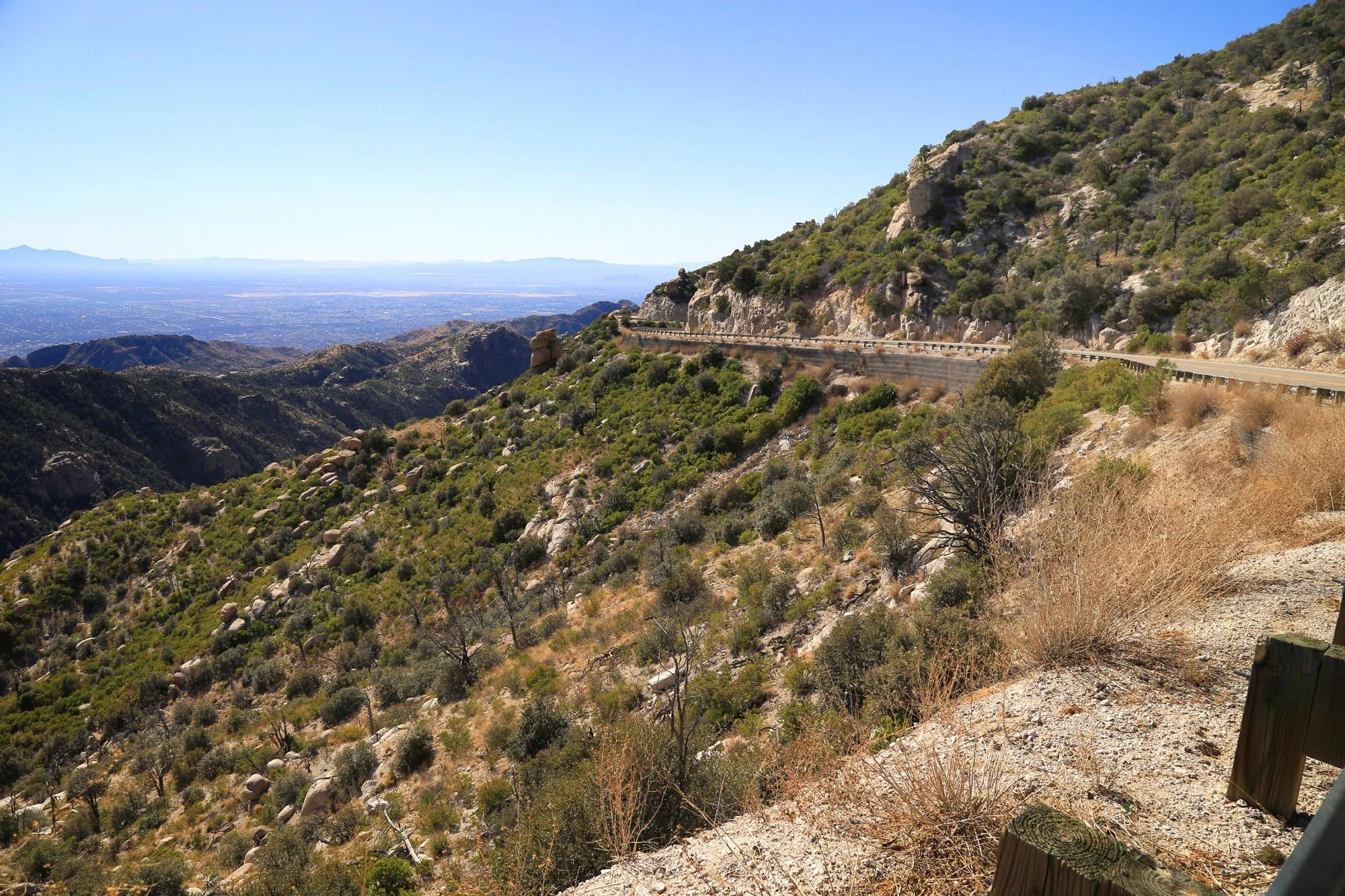
Catalina Highway also appears on maps as General Hitchcock Highway and the Sky Island Scenic Byway. Arizona Highways describes the drive from its junction with Tanque Verde Road to Summerhaven as approximately 30 miles one way. Shorter distances in other guides usually describe the mountain segment from a different starting point. Do not treat a guide’s total mileage as the number on a highway milepost.
Plan to return down the same paved road. That makes this an easy trip to shorten: turn around after the overlooks if that is enough, or continue into the upper forest if everyone is enjoying the climb. The unpaved Control Road toward Oracle is a separate, rougher outing, not a comparable shortcut for a casual scenic drive.
Start with water, food and enough fuel for the outing, and leave room in the schedule for slow curves and stops. Cyclists use this road too. Give them space, follow posted speeds and pull fully into designated parking areas before taking photographs. A view is never a reason to stop in a travel lane.
For a first visit, reserve most of a day rather than calculating the trip from nonstop driving time. Our suggested rhythm is two or three overlooks, a forest stop and Summerhaven. Choose either the lake or the summit extension if you want more; trying to add both can crowd out the unhurried stops that make the drive rewarding.

Sources: Arizona Highways: Catalina Highway, by Noah Austin · Forest Service: Control Road #38 · Visit Arizona: Mount Lemmon · Visit Tucson: Mount Lemmon day-trip guide
Watch the landscape change as you climb
The lower slopes still belong to the Sonoran Desert. Saguaros mark the hillsides, while the road bends into progressively different vegetation. Higher up, the open desert gives way to scrub and woodland; eventually ponderosa pines become a defining part of the view. Near the upper mountain, mixed conifers and pockets of aspen make the surroundings feel very different from Tucson.
Western National Parks describes an ascent of more than 6,000 feet along the mountain highway. That helps explain why checking only Tucson’s forecast is inadequate. Take a layer you can put on at a breezy overlook or in the upper forest, even when the valley feels warm. The temperature difference varies with conditions; a fixed number of degrees would be a poor packing plan.
If you enjoy knowing what you are looking at, consider the University of Arizona’s Mount Lemmon Science Tour. Visit Tucson links the audio tour and its app-store options. Check compatibility and download what you need before leaving; the current tourism page says the app is free to download but tour content requires payment. It is an optional companion, not essential equipment.
There is also a longer human history behind the scenic-road experience. Western National Parks identifies the Tohono O’odham name Babad Do’ag and the mountain’s continuing importance to Indigenous communities. Treat the forest as a lived-in and cared-for landscape, rather than an empty backdrop for a photograph.
Sources: Western National Parks: Palisades Visitor Center · Arizona Highways: Catalina Highway, by Noah Austin · Visit Tucson: Mount Lemmon and science tour · University of Arizona: Explore Tucson
Make Windy Point your first substantial pause
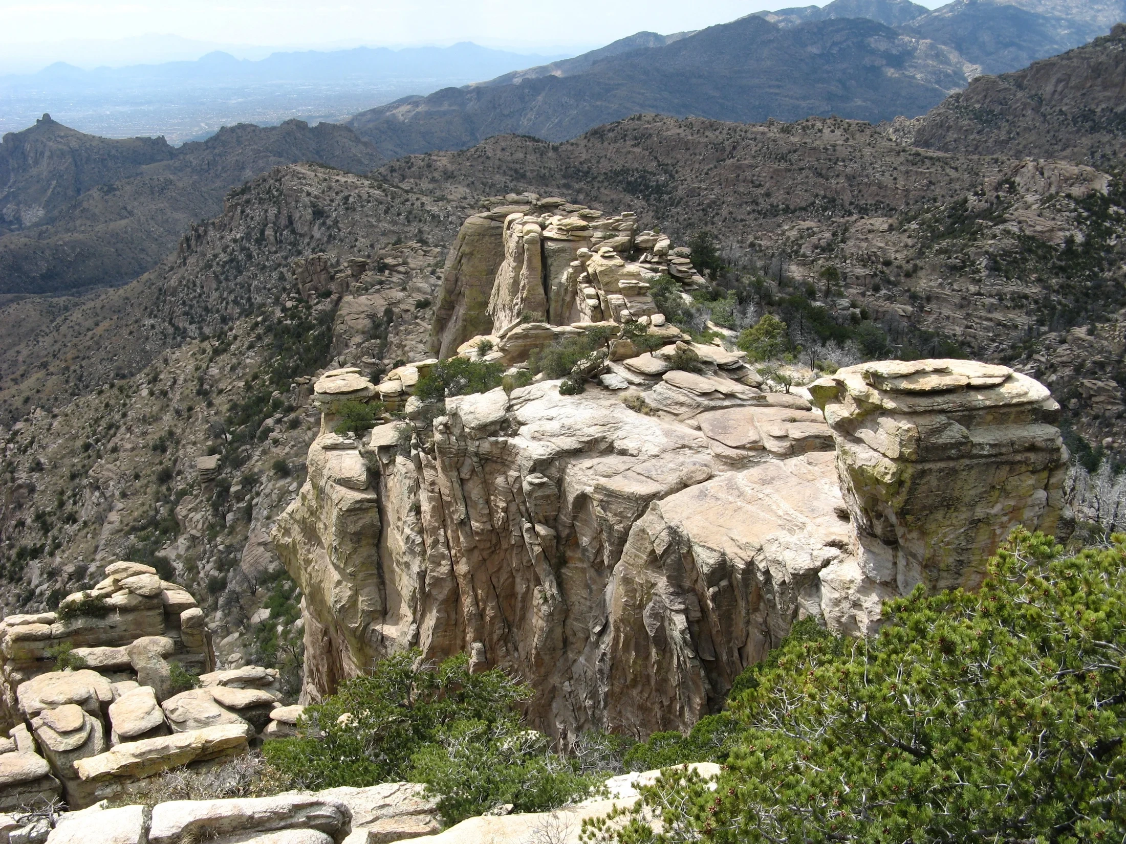
Windy Point is the stop to choose when you want a big change of perspective without committing to a trail. Rock towers occupy the foreground, the mountain slopes fold away below them and Tucson spreads across the distance. The view makes the climb visible: this is where the road starts to feel like a journey above the city.
The Forest Service lists no fee and vault toilets here. That combination makes it a useful pause as well as a scenic one, but it does not guarantee a vacant parking space. If the lot is full, continue to a designated place where you can safely stop or turn around. Do not improvise a roadside space because someone else has done so.
You can appreciate the scenery without scrambling out onto the formations. Keep your outing within the developed viewing areas and choose where to stand according to the surface, weather and your own comfort with exposure. This guide does not classify the whole viewpoint as an accessible route.
Geology Vista is another no-fee option farther along the climb, although it has no restroom. You do not need to stop at every pullout. Pick the outlook that has legal parking and lets you spend a few minutes actually looking; save another for the descent if conditions and time allow.
Sources: Forest Service: Windy Point · Arizona Highways: Catalina Highway, by Noah Austin · Forest Service: Geology Vista · Visit Tucson: Mount Lemmon day-trip guide
Use Palisades to shift into a forest day
By the upper highway, the appeal changes from looking across the landscape to spending time within it. Palisades Visitor Center, at milepost 19.9, is a useful place to make that shift. When it is open, ask about the day’s conditions and choose a walk that fits your time, footing and energy rather than relying on an old trail roundup.
The Forest Service lists flush toilets and potable water here, and Western National Parks operates the store. Those facilities are worth knowing about because many nearby picnic and recreation sites list no drinking water. Bring your own supply regardless; a visitor-center stop should be helpful, not the only thing making your plan work.
Continue toward Aspen Vista for a different outlook from Windy Point. Arizona Highways describes the view opening northward here, while the Forest Service lists no fee and no restroom. The name is not a promise of peak fall color. Foliage depends on elevation and the season’s conditions, and the pine forest is worth visiting without an autumn spectacle.
If a picnic matters more than another overlook, Inspiration Rock is a documented option with tables and vault toilets. Its listed charge is $8 per vehicle for a day, with accepted forest or interagency passes described on the site page. There is no potable water. Bring a meal that does not depend on lighting a fire, and check the current site rules before setting up.
Sources: Forest Service: Palisades Visitor Center · Western National Parks: Palisades Visitor Center · Forest Service: Aspen Vista · Arizona Highways: Catalina Highway, by Noah Austin · Forest Service: Inspiration Rock Picnic Area
Choose Rose Canyon if you want water and pines
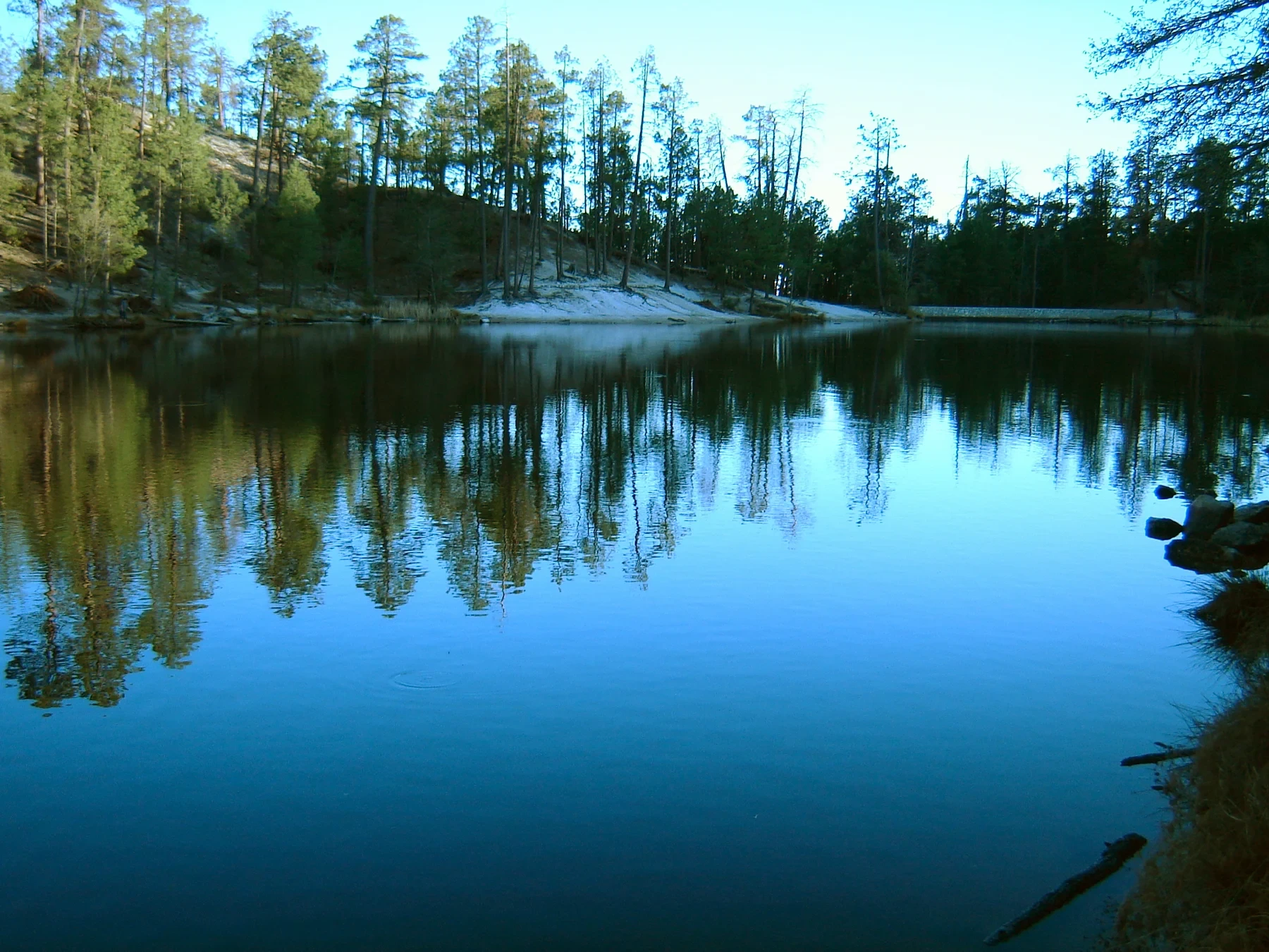
Rose Canyon Lake gives the trip a different texture: a small body of water framed by trees rather than another distant panorama. The Forest Service describes a six-acre trout lake in ponderosa forest. It is a good optional branch of the day for someone who would enjoy lingering at the shore more than adding another high viewpoint.
The approach leaves the main highway and goes through the campground to a small parking area, followed by a short walk to the lake. This is an additional outing, not a drive-by overlook. The current site page lists an $11 vehicle day-use fee. Concession charges and forest passes are not interchangeable, so check the lake’s own fee information instead of assuming a pass covers it.
Keep this a shore visit. An active Forest Service order prohibits entering or being in or on the lake; it is not a swimming or paddling stop. Fishing has its own rules and requirements, which should be checked separately if that is your purpose.
The manager identifies an accessible route between the lower parking area and the floating dock near the dam. That does not establish that the entire shoreline walk is accessible. No potable water is listed, and winter vehicle access depends on the seasonal gate and weather. When the gate is closed, the effort needed to reach the lake changes substantially; skip it unless you have deliberately planned the walk.

Sources: Forest Service: Rose Canyon Lake · Forest Service: Rose Canyon Lake water restriction · Forest Service: Coronado passes
Let Summerhaven be a break, not another checklist
Summerhaven is the point where a day of road and forest can settle into food and a little time on foot. The village has a general store and places to eat, including the Cookie Cabin and Sawmill Run. Choose based on the day’s opening hours and what you want, rather than arriving with a promise of a particular meal at a particular time.
The Mount Lemmon General Store lists food and other supplies, along with its fudge, and posts daily hours on its own site. It can be a practical stop as well as a treat. Those hours do not apply to neighboring restaurants, and availability can change. Keeping a snack in the car means a queue or closure does not dictate the afternoon.
Parking is part of the visit. Pima County’s earlier congestion study documents how the small center and street system can struggle with vehicles and pedestrians, and current Forest Service guidance still warns that upper-mountain parking fills. Use signed spaces and avoid blocking access to cabins, businesses or roads. Plan to enjoy the village at walking pace once parked.
For a straightforward first trip, this can be your turnaround. You will already have experienced the full transition from desert slopes to mountain forest. There is no need to add the summit just to make the day count.
Sources: Mount Lemmon General Store: mountain contacts · Mount Lemmon General Store: visitor questions · Pima County: Summerhaven congestion study · Forest Service: upper Catalina Highway recreation
Treat the summit and Marshall Gulch as conditional extras
Ski Run Road branches toward Ski Valley and the upper mountain. The resort offers a scenic chairlift ride outside ski season, but its operator lists Tuesday and Wednesday closures and warns that weather can halt ticket sales. The site gives inconsistent exact hours across its pages, so confirm the operating window for your date before making the lift the centerpiece of the trip.
The Mount Lemmon Day Use Area lies beyond Ski Valley near the summit. The Forest Service describes conifers, aspens, picnic tables and nearby trails, with limited dirt parking and limited accessibility on gravel surfaces. It also notes a winter gate at Ski Valley. Reaching Summerhaven does not necessarily mean you can drive all the way to the upper day-use area. Do not block the observatory gate or assume the astronomy facilities are open for an unbooked visit.
Marshall Gulch needs a separate caution as of October 16, 2026. The active Forest Service alert lists Monday–Thursday construction closures through December 17, with specified trails open to pedestrians on Fridays, weekends and federal holidays. A county project page says work was completed earlier, while the general recreation page also contains older access language. Those conflicting updates are not a basis for promising unrestricted access or parking.
This itinerary therefore works without Marshall Gulch. If you specifically want that trail network, check the current order and on-site notices first. Do not follow a generic recommendation for an easy forest walk into a closed work area.
Sources: Mount Lemmon Ski Valley: current operations · Mount Lemmon Ski Valley: Sky Ride · Forest Service: Mount Lemmon Day Use Area · Forest Service: Marshall Gulch closure order 03-05-05-26-009 · Pima County: Sabino Canyon Park and Marshall Gulch project · Forest Service: Marshall Gulch Picnic Area
Build the day around the season you actually have
A warm Tucson afternoon can make the upper forest an appealing escape, but the mountain has its own weather and access constraints. Before leaving, check the Coronado National Forest alerts and the Pima County road condition hotline at 520-351-3351. The Forest Service publishes that number for current road information. An old social-media photo or a clear view of the summit does not establish road access.
In winter, snow can close the highway or bring vehicle traction requirements. Separately, gates can limit access to places such as Rose Canyon or the summit area. In summer, weather can interrupt lift operations and change whether exposed viewpoints are a sensible stop. In autumn, enjoy whatever color is present without assuming a precise peak date. None of these seasons requires forcing the same itinerary.
For a short version, choose Windy Point, one upper-forest stop and Summerhaven. For a longer version, add Rose Canyon if its vehicle gate is open, or the summit area if its road and facilities suit your plans. These are our planning suggestions, not timed tours. Leave enough daylight and attention for the descent, especially if you are unfamiliar with the road.
If the weather changes the plan, a lower-elevation day in Tucson is still a worthwhile trip. Our Arizona gardens guide offers other ways to spend time with the region’s plants. If the mountain makes you curious about staying after dark, the separate Arizona astronomy guide explains organized night experiences. Keep that as a deliberately planned outing rather than an improvised extra at the end of a long drive.
Sources: Coronado National Forest: active alerts · Forest Service: Mount Lemmon Ski Valley · Forest Service: Rose Canyon Lake · Forest Service: Mount Lemmon Day Use Area · Mount Lemmon Ski Valley: current operations
The details
A few good questions.
Is Catalina Highway paved?
The main route from Tucson toward Summerhaven and Ski Valley is paved. The Control Road toward Oracle is a separate unpaved route and is not included in this day plan. Weather closures and vehicle restrictions can still apply to the paved highway.
Do you need to pay to stop along the drive?
Several viewpoints, including Windy Point, Geology Vista and Aspen Vista, list no site fee. Developed picnic sites and Rose Canyon have their own charges or pass rules. Check the specific destination rather than assuming one fee covers the whole mountain.
Can you swim in Rose Canyon Lake?
No. The current Forest Service order prohibits being in or on the lake. Plan for shore viewing, or check the separate requirements if you intend to fish.
Can you do the drive without hiking?
Yes. The changing scenery, designated viewpoints and Summerhaven can fill a day without a trail hike. Parking surfaces and short walks vary; check individual facilities if you need a particular level of access.
Behind the story
Sources & further reading.29 sources behind this story
Research reviewed October 16, 2026. Check the linked providers for updates before travel.
Researched and written with AI, with automated editorial review. Read how we check our stories.
- Forest Service: upper Catalina Highway recreationChecked 2026-10-16
- Forest Service: Windy PointChecked 2026-10-16
- Forest Service: Rose Canyon LakeChecked 2026-10-16
- Forest Service: Palisades Visitor CenterChecked 2026-10-16
- Forest Service: Marshall Gulch Picnic AreaChecked 2026-10-16
- Forest Service: Mount Lemmon Day Use AreaChecked 2026-10-16
- Forest Service: Control Road #38Checked 2026-10-16
- Forest Service: Marshall Gulch closure order 03-05-05-26-009Checked 2026-10-16
- Pima County: Sabino Canyon Park and Marshall Gulch projectChecked 2026-10-16
- Western National Parks: Palisades Visitor CenterChecked 2026-10-16
- Arizona Highways: Catalina Highway, by Noah AustinChecked 2026-10-16
- Visit Tucson: Mount Lemmon day-trip guideChecked 2026-10-16
- Visit Arizona: Mount LemmonChecked 2026-10-16
- Mount Lemmon General Store: mountain contactsChecked 2026-10-16
- Coronado National Forest: active alertsChecked 2026-10-16
- Forest Service: Geology VistaChecked 2026-10-16
- Forest Service: Aspen VistaChecked 2026-10-16
- Forest Service: Rose Canyon Lake water restrictionChecked 2026-10-16
- Forest Service: Mount Lemmon Ski ValleyChecked 2026-10-16
- Mount Lemmon Ski Valley: current operationsChecked 2026-10-16
- University of Arizona: Explore TucsonChecked 2026-10-16
- Forest Service: Coronado passesChecked 2026-10-16
- Forest Service: Inspiration Rock Picnic AreaChecked 2026-10-16
- Mount Lemmon Ski Valley: Sky RideChecked 2026-10-16
- Pima County: Summerhaven congestion studyChecked 2026-10-16
- Visit Tucson: Mount Lemmon and science tourChecked 2026-10-16
- Mount Lemmon General Store: visitor questionsChecked 2026-10-16
- Photograph license: CC BY-SA 3.0Checked 2026-10-16
- Road photograph license: CC BY-SA 4.0Checked 2026-10-16
Your next somewhere.
U.S. travel stories with sources you can follow and places worth making time for.
Our editorial approachExplore destinationsShare a little inspiration